PL EN

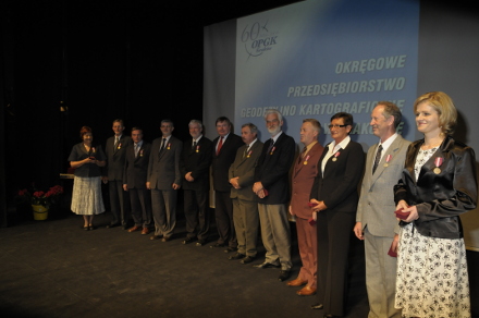
70 YEARS OF TRADITION

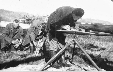
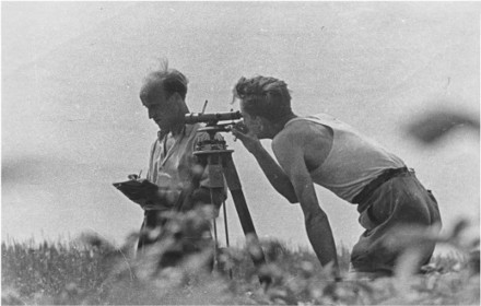
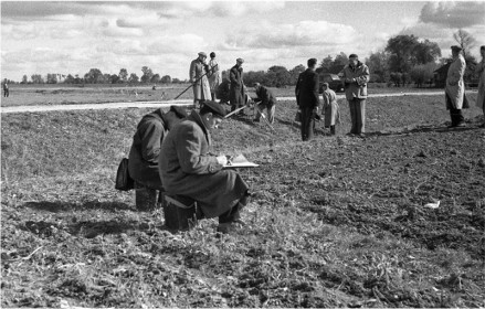
Rome wasn’t built in a day (in Poland we say “Krakow wasn’t built in a day”) – it is a famous phrase accurately referring to the history of the company which today operates under the name: The Kraków Surveying & Cartographic Company Ltd. (OPGK Kraków Sp. z o.o.). Before OPGK Kraków became what it is today, it underwent a long process involving numerous, multi-lane transformations, names of the company and its organizational units changed many times. Over the time those units created one entity.

HISTORY


Based on the Order passed on the 9th of February 1949 on the establishment of State Geodetic Enterprise, the first post-war state-owned geodetic enterprise - Krakow Branch of the State Geodetic Enterprise in Warsaw (KOPPM) was founded in Krakow.

The scope of activities of this newly created company covered the south - eastern region of Poland. After the establishing other subsequent activities took place, Krakow Branch was entrusted to mgr inż. Zbigniew Skąpski who was appointed to be the first director of the Branch. A few days later an important historical fact occurred - KOPPM received its first order. The order involved preparation of map in scale 1: 5000 and 1:10 000 due to the project involving the construction of New Steelworks (Nowa Huta) and covering the area of approx. 3,000 hectares.

We are still in 1949. At that time National Photogrammetry and Cartography Company (PPFK) was founded in Warsaw based on the decision of the Central Office for National Measurement. The fact is even more significant as soon after (in March 1950) the Branch of PPFK was established in Krakow – it was a unit which now could be called vividly as one of the roots of today’s Department operating in Krakow. So, for some time in Krakow there were two "sister companies". After a year and a half the Branch of PPFK became an independent unit operating under the name Krakow Regional Cartographic Company (KOPK). In the same year, that is in 1951 the Branch of KOPPM in Krakow became independent, started operating separately as Krakow Regional Measuring Department (KOPM).
Both companies which were autonomous since 1951 would soon create one enterprise. In 1953 KOPM incorporated KOPKE creating an independent organizational unit called III Photogrammetric Department. This department, despite the fact that it functioned within the structure of KOPM, kept its previous structure. This unit was almost ideal as it enabled surveying and mapping realized by one entity.

On the 1st of January 1954 the Manufacturing Department of Geodetic Enterprises for Public Utilities "East" in Warsaw (WPPGGK) started operating near Wawel. This was the beginning of the period of balance as regards the organizational work, at that time in Krakow there were three companies offering a similar scope of services. It was not until the1st of January 1974 when based on a decision of the state KOPM and WPGGK were merged creating a The Kraków Surveying & Cartographic Company Ltd. On that day a geodetic company founded based on already known companies appeared on the domestic market under a new banner and today it still uses the same name.

Mgr inż. Adam Koncewicz was the director of the company since 1962. Under his leadership, the company reached its development peak employing nearly 1,500 people in late seventies.

The main organizations within the structure of the company has always included manufacturing facilities: Department of Photogrammetry, Municipal Geodesy Department, Department of Construction Surveys, Topo – Karto Department. Moreover, the following units were operating as well: Department of Cartographic Reproduction, Department of Autogrametric Studies, Department of Computer Science and ETO (Electronic Measurement Technique), Field Branch in Tarnow, Nowy Sacz and Zakopane. People working in OPGK Kraków identified themselves with those divisions and branches, production tasks were assigned to these units, they “guaranteed” their own success and the success of the entire company.

In 1992, after 30 years of managing the company, the director Adam Koncewicz retired. In the result of the contest mgr inż. Zbigniew Głogowski took his place. Privatization negotiations with the Ministry of Spatial Planning and Construction proceeded very smoothly and on the 6th of December 1993 the company under the name of The Kraków Surveying & Cartographic Company Ltd. was registered in the District Court for Krakow Srodmiescie. It started its operations on the 1st of March 1994 by taking over the lease as regards the liquidated assets of the state enterprise under the same name.
In 1999 the company celebrated its anniversary: 50 years of existence. Celebrations were held in one of the most renowned buildings in Krakow - the Theatre named after Juliusz Słowacki.

After the greetings and speeches made by VIPs, on the stage a ceremony honoring the dedicated employees of OPGK Kraków took place. The honored ones received state and company’s medals "For their devotion to OPGK Kraków." A total of 37 people were decorated.

A cocktail party was organized in cultural and at the same time relaxed atmosphere of the theater foyer, the hosts and guests conducted vivid conversations about “the past" and the prospects for the future. The future, which is now the present.

Period 2000-2002 meant continuing investment in technology, especially digital photogrammetry and GIS.
The prospect of new tasks connected to Polish accession to the European Union found us prepared both from technological and organizational point of view. We had already had first experiences in tasks such as LPIS concerning an object with a high degree of difficulty.
To ensure the maintenance and improvement of the quality as regards our projects and services, we have implemented the Quality Management System according to ISO 9001: 2000.

The first years after joining the EU in 2004 constituted a period of great projects organized by the Agency for Restructuring and Modernisation of Agriculture and the Head Office of Geodesy and Cartography. OPGK Kraków have conducted audits concerning direct supplementary payments and the modernization of LPIS throughout Poland. Cartography industry started accelerating dynamically and underwent changes. Topographical database based on GIS technology was created. The construction of the dam Świnna Poreba serviced by our company reached its final stage.

On 28.06.2012, as a result of the vote at the Annual Meeting of Shareholders, the Management Board was appointed. It consisted of: Robert Rachwał - Chairman of the Board, Agnieszka Buczek – Vice-Chairman of the Company.

ANNOUNCEMENTS

GDPR information clause

CERTIFICATES

CONTACT

ul. Karola Łowińskiego 7E
31-752 Kraków

Tel. 12 421-09-83
Tel. 12 421-41-22
Fax. 12 421-76-80

e-mail: opgk@opgk.krakow.pl